Analysis: What's behind the Observatory objection?
At the last Parish Council meeting there was a sense of puzzlement, amongst some Councillors, over the Observatory’s objection to the 75-home planning application.
Here we explain the background to that objection.
Lodged by the Science and Technology Facilities Council (STFC) which runs the Observatory, the objection includes a note from the National Space Operations Centre (NSpOC). It says:
The Chilbolton Observatory supports NSpOC with the provision of sensor services to provide observations of artificial space objects under the National Programme as tasked by NSpOC. This involves the radar dish CASTR and the COATS optical telescope. The services at Chilbolton also include the transfer of sensor data to NSpOC to assist in the objects orbit determination and contribute to SDA services.
Any development that could degrade the Observatory’s current and future capabilities could impact NSpOC’s mission sets that support the UK’s space surveillance and protection.
Admittedly, this includes some odd acronyms which might give rise to the puzzlement.
We will explain what CASTR, COATS, SDA and NSpOC are, and why they are critically important for safety and security in the UK. 1
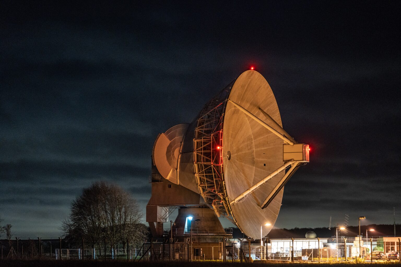
Chilbolton Observatory (Credit: National Centre for Atmospheric Science)
Developing capability at the Observatory
The Chilbolton Observatory, sitting on a 76 hectare (188 acres) site 2, has conducted research since 1967. Until 2010 it was mainly concerned with atmospheric and ionospheric science-based research. The 25 metre antenna - the “dish” - is the world’s largest fully steerable meteorological radar, using a sensor known as Chilbolton Advanced Meteorological Radar (CAMRa).
Initial satellite tracking
In 2010, work was undertaken to modify CAMRa to track satellites in support of the European Space Agency’s Space Situational Awareness Preparatory Programme. A total of 40 satellites were observed and their tracks plotted. 3
Following this, a second dedicated radar was added to the antenna. Known as Chilbolton Advanced Satellite Tracking Radar (CASTR), it could detect objects as small as 1 square metre in low earth orbit, up to 2,500km away. 4
Combining with optical and laser systems
In 2014, experiments demonstrated that radar tracking could be combined with data from optical and laser systems in Australia to refine methodologies for orbit determination. 5
In 2016 scientists extended that work and demonstrated that a telescope connected to an agile mount, known as Chilbolton Optical Advanced Tracking System (COATS), could be used to position CASTR to detect multiple satellites.
The same team were also able to show that the satellite laser ranger at the Space Geodesy Facility, Herstmonceux, could also drive CASTR. 6
Greater sensitivity
In addition to improving the techniques of tracking, scientists and engineers also increased the sensitivity of the detector to the extent that it was capable of resolving objects of only 10cm at an altitude of more than 3,500km. 7
This enhanced capability meant that the Chilbolton facility was able to provide valuable tracking data to the UK Space Agency’s Space, Surveillance and Tracking team over many years. 8
Tracking satellite re-entry
The capability of the system was demonstrated in 2023 when CASTR was used to track the re-entry of the Aeolus satellite which had been used to measure global wind patterns.
The UK Space Agency said of the tracking from Chilbolton: 9
It is unusual for sensors of this size to be able to track events like this due to the often low elevations, the speed the debris crosses the sky needed and changes to predicted paths caused by atmospheric effects upon the object as it descends towards the Earth’s atmosphere, so the data collected by CASTR provides valuable information to analyse the projected final re-entry.
The controlled re-entry was the first of its kind, and the Chilbolton Observatory performed “a task no other sensor in the UK could perform during the re-entry process”. 10
Funding
As part of “levelling-up” funding for the UK Space Sector in 2023, Chilbolton received more funding. Announcing it, the Government said: 11
The £6.5 million includes £485,000 for STFC RAL Space’s Chilbolton Advanced Satellite Tracking Radar, in Hampshire, is one of three national sensors that track space objects. The radar which can detect objects about the size of a toaster at an altitude of 1,000 km, provides crucial data for satellite tracking operations. The funding will provide upgrades to improve reliability and robustness of the sensor and maintain a key sovereign asset.
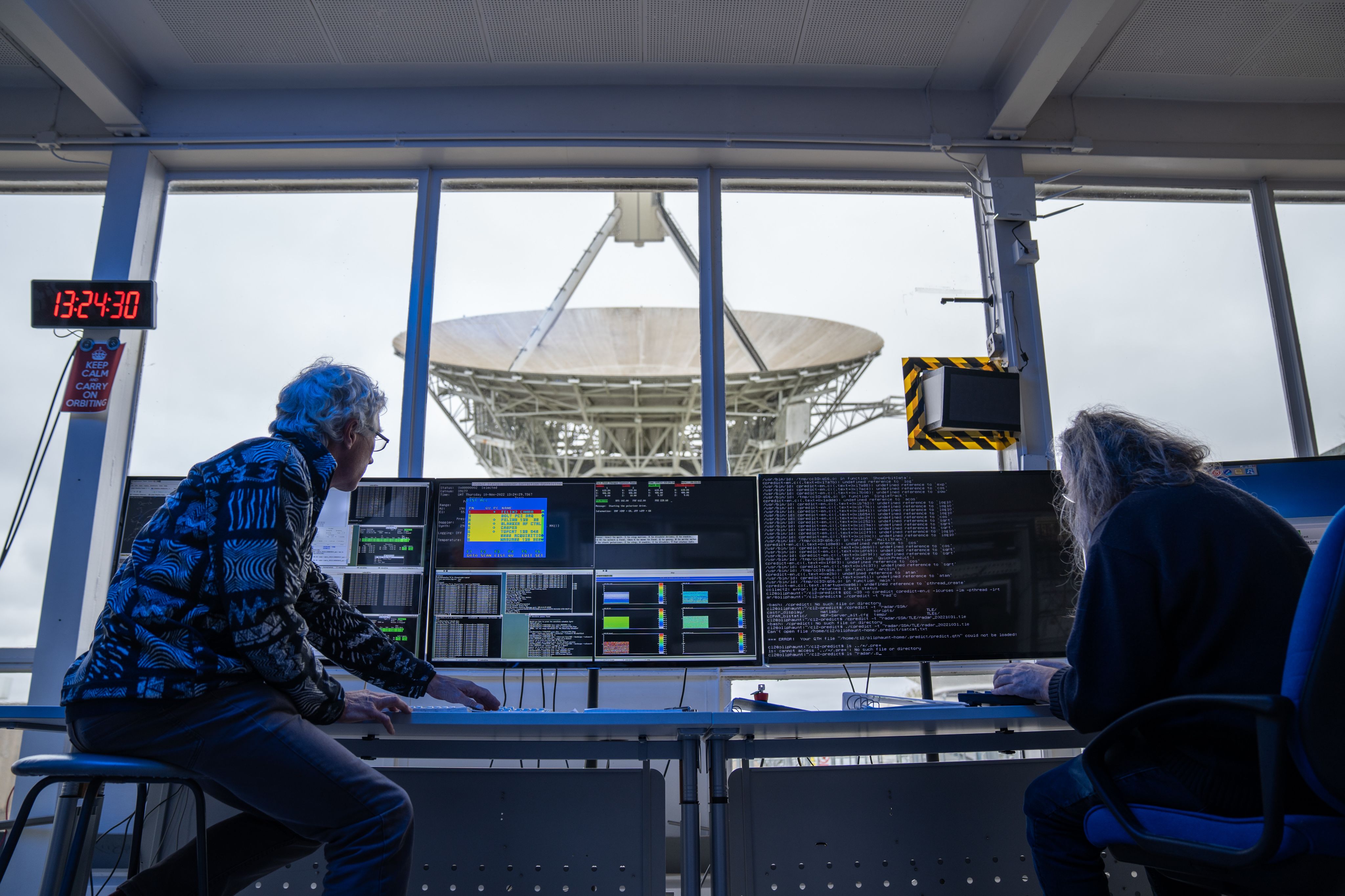
Chilbolton Observatory control room (Credit: National Centre for Atmospheric Science)
Space Domain Awareness
The 2021 UK National Space Strategy (NSS) identified eight key civil and defence capability priorities. One of these was the need to develop Space Domain Awareness (SDA): the “detection, identification, and tracking of objects in space… to ensure that the UK has knowledge of what is occurring in space”. 12
The UK Space Agency commissioned a report in 2022, which began with a worrying warning: 13
The UK ranks in the bottom half of G20 nations in terms of general space sector spending and the majority of UK space funding is applied to the military, in contrast to many other nations. It has a relatively small number of sensor capabilities and is largely reliant on other nations for SDA data and services.
Sovereign SDA assets
The report assessed the “sovereign” satellite sensors available for SDA: 14
-
Radar
- Solid-State Phased Array Radar at RAF Fylingdales
- Chilbolton Advanced Satellite Tracking Radar
-
Optical
- Chilbolton Optical Advanced Tracking Sensor
- Starbrook telescope in the Troodos mountain range in Cyprus.
-
Laser
- Space Geodesy Facility at Herstmonceux
The report recommended that: 15
- The UK should invest in the procurement of more sovereign sensors to improve its sensing capability and international credibility as well as contribute to closing gaps in global capability
- A national space operations centre, bringing together the civil, military, and commercial sectors would allow for the collection, consolidation, and exploitation of [Space Surveillance and Tracking] data to produce high quality analytical products for a range of users
Launch of NSpOC
On 16 May 2024, the National Space Operations Centre (NSpOC) was formally established to operate the UK’s space surveillance and protection capabilities, including the work done at Chilbolton Observatory.
Its mission sets include: 16
- protecting and defending the UK’s space interests
- missile warning
- uncontrolled re-entry early warning
- in-space collision avoidance
- fragmentation alerting and monitoring
- support to licence monitoring
- space weather notifications and advice
Chilbolton Observatory’s role in this is to provide “high-precision radar and optical observations directly to NSpOC, enabling real-time tracking of satellite movements and supporting NSpOC’s mission to safeguard national space assets.”
The Rutherford Appleton Laboratory report of 2024 says: 17
“By delivering high-resolution tracking of satellites and debris, with more precise characterisation capabilities under development, Chilbolton Observatory plays a critical role in NSpOC’s capacity to maintain space domain awareness and secure UK space interests.”
Objection to the 75-home development
A unique and critical role
The work done by the Observatory in its role of providing tracking data to NSpOC is unique. No other UK sovereign asset can do what it does.
The information is also critical in assessing threats from objects orbiting the planet.
A key feature of the UK’s SDA approach was that it draws information from a variety of sensors in different locations to a centralised System of Systems (SoS). This pooling of resources creates a more complex system which offers more functionality and performance than its individual components.
It’s also important to note that NSpOC has been tasked with dual use responsibilities - it supports both civil and military objectives. 18
These objectives are what STFC’s objection refers to when it says “any degradation of [Chilbolton Observatory’s] situation is a loss to wider UK science and specifically UK space domain awareness capabilities”."
Low elevations are important
Being able to track satellites at low elevations is important, as was demonstrated by the tracking of the re-entry of the Aeolus satellite. Building houses to the North of the Observatory will degrade observations in that direction.
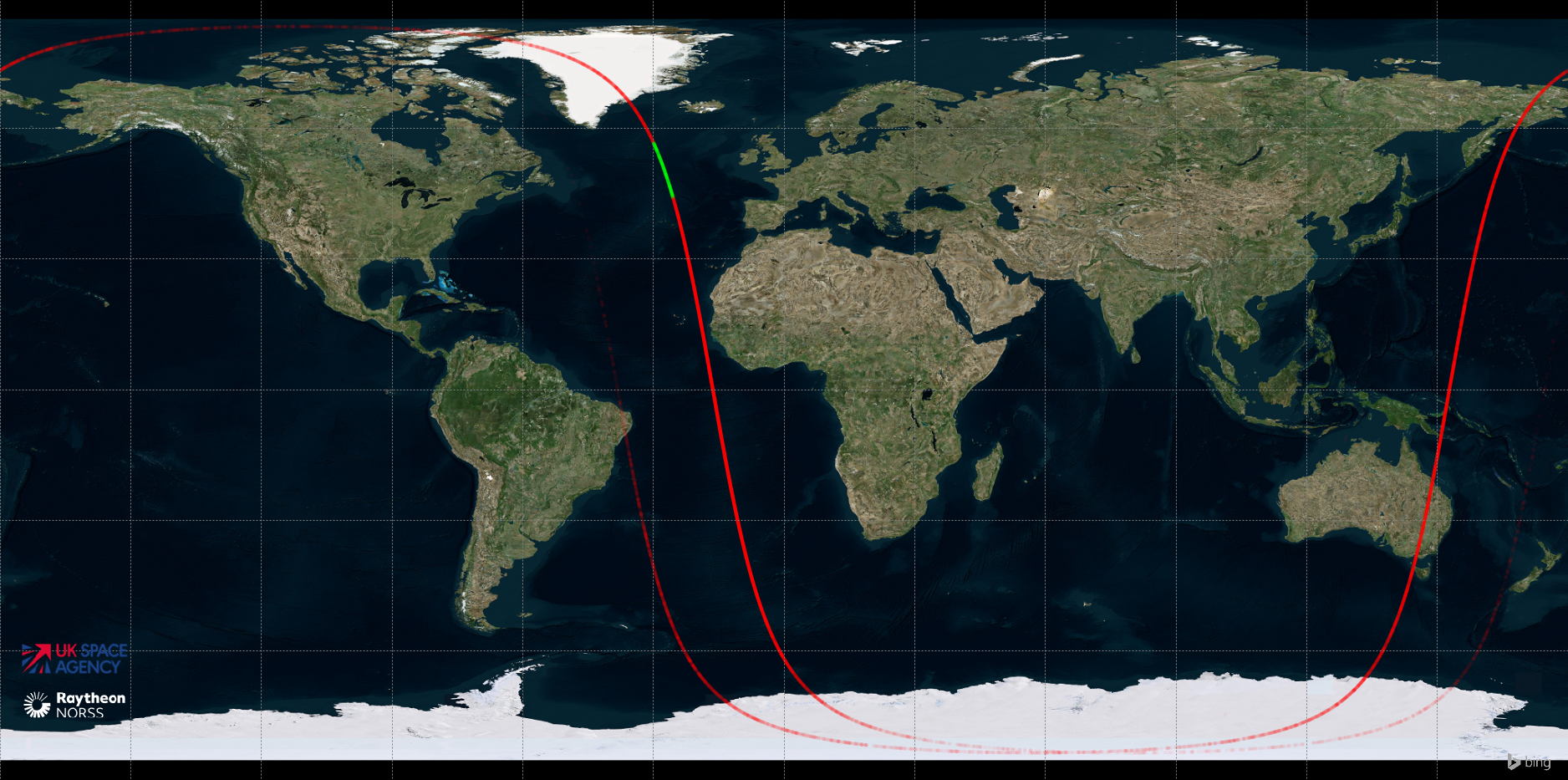
Red line depicts potential re-entry locations of the Aeolus satellite (Credit: UK Space agency)
Sensitive detectors
Over the years the satellite detector within CASTR has been upgraded to be able to detect smaller objects. This makes observation more sensitive to electromagnetic interference, including those from homes and vehicles.
The STFC objection states that “an upgrade to the facility is currently being planned which will deliver a more sensitive sensor”.
Currently the CASTR sensor can apparently detect a 10cm object at an altitude of more than 3,500km. Given that collision with even tiny amounts of space debris can prove fatal, it wouldn’t be surprising if NSpOC were to set an objective of detecting objects as small as 1cm.
Summary
The work done at Chilbolton Observatory rests on years of science and engineering at the site. The value of that work and its uniqueness are the reason it has been incorporated into the UK’s Space Domain Awareness programme.
It would be a reckless act to allow degradation of such an important asset. As the STFC objection says “The most robust mitigation is no further development in the vicinity”.